Everglades Depth Estimation Network (EDEN) for Support of Biological and Ecological Assessments
Users can obtain two types of water-depth data using EDEN:
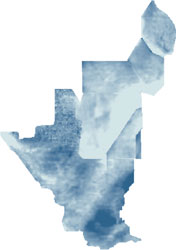
Example EDEN water-depth map.
Users can download daily water-depth maps 1) in the table below and 2) through the EDEN THREDDS Data Server. The EDEN project also provides a tool, Depth&DaysSinceDry, that allows users to create their own daily water-depth maps by using the EDEN water surface and ground elevation model (DEM) netCDF files. Daily water-depth maps are computed by subtracting the ground elevation from the daily water level for each EDEN grid cell (400 meters by 400 meters); negative water level values are shifted to zero.
EDEN surfaces are served mainly as NetCDF (Network Common Data Form) files, a set of freely-distributed software libraries and machine-independent binary data formats that support the creation, access, and sharing of large array-oriented scientific data. Each file contains 3 months (one quarter-year) of daily datasets. For example, the data for every day in 2020 will be stored in 4 files: 2020_q1_depth.nc, 2020_q2_depth.nc, 2020_q3_depth.nc, and 2020_q4_depth.nc.
| Water-Depth NetCDF Files
File naming conventions:
Note: You may download a year's worth of data all at once. Simply click the link below for each year. Because of file size limits, the most you can download at one time is a year. If you need to download several year's worth of data at once, please contact Bryan McCloskey (bmccloskey@usgs.gov) and other arrangements can be made. |
||||
|---|---|---|---|---|
| Date | 1/1 - 3/31 | 4/1 - 6/30 | 7/1 - 9/30 | 10/1 - 12/31 |
| 2024 | Real-Time Data | Real-Time Data | ||
| 2023 (zip, 37 MB) |
2023 Q1 (zip, 11.7 MB) v3prov |
2023 Q2 (zip, 11.5 MB) v3prov |
2023 Q3 (zip, 14.3 MB) v3prov |
Real-Time Data |
| 2022 (zip, 51 MB) |
2022 Q1 (zip, 12.4 MB) v3prov |
2022 Q2 (zip, 10.8 MB) v3prov |
2022 Q3 (zip, 14.1 MB) v3prov |
2022 Q4 (zip, 14.2 MB) v3prov |
| 2021 (zip, 50 MB) |
2021 Q1 (zip, 13.5 MB) v3 |
2021 Q2 (zip, 8.9 MB) v3 |
2021 Q3 (zip, 13.7 MB) v3 |
2021 Q4 (zip, 14.2 MB) v3prov |
| 2020 (zip, 48 MB) |
2020 Q1 (zip, 10.8 MB) v3 |
2020 Q2 (zip, 8.4 MB) v3 |
2020 Q3 (zip, 14.2 MB) v3 |
2020 Q4 (zip, 14.6 MB) v3 |
| 2019 (zip, 49 MB) |
2019 Q1 (zip, 11.6 MB) v3 |
2019 Q2 (zip, 10.4 MB) v3 |
2019 Q3 (zip, 14 MB) v3 |
2019 Q4 (zip, 12.7 MB) v3 |
| 2018 (zip, 50 MB) |
2018 Q1 (zip, 12.4 MB) v3 |
2018 Q2 (zip, 10.2 MB) v3 |
2018 Q3 (zip, 14.2 MB) v3 |
2018 Q4 (zip, 12.7 MB) v3 |
| 2017 (zip, 48 MB) |
2017 Q1 (zip, 10.4 MB) v3 |
2017 Q2 (zip, 8.7 MB) v3 |
2017 Q3 (zip, 14.3 MB) v3 |
2017 Q4 (zip, 14.5 MB) v3 |
| 2016 (zip, 55 MB) |
2016 Q1 (zip, 14 MB) v3 |
2016 Q2 (zip, 13.1 MB) v3 |
2016 Q3 (zip, 14.2 MB) v3 |
2016 Q4 (zip, 13.7 MB) v3 |
| 2015 (zip, 44 MB) |
2015 Q1 (zip, 10.7 MB) v3 |
2015 Q2 (zip, 8 MB) v3 |
2015 Q3 (zip, 11.5 MB) v3 |
2015 Q4 (zip, 13.8 MB) v3 |
| 2014 (zip, 48 MB) |
2014 Q1 (zip, 12.2 MB) v3 |
2014 Q2 (zip, 8.2 MB) v3 |
2014 Q3 (zip, 13.7 MB) v3 |
2014 Q4 (zip, 13.5 MB) v3 |
| 2013 (zip, 51 MB) |
2013 Q1 (zip, 11.1 MB) v3 |
2013 Q2 (zip, 12 MB) v3 |
2013 Q3 (zip, 14.3 MB) v3 |
2013 Q4 (zip, 13.9 MB) v3 |
| 2012 (zip, 50 MB) |
2012 Q1 (zip, 10.8 MB) v3 |
2012 Q2 (zip, 10.8 MB) v3 |
2012 Q3 (zip, 14.2 MB) v3 |
2012 Q4 (zip, 14.1 MB) v3 |
| 2011 (zip, 39 MB) |
2011 Q1 (zip, 8.9 MB) v3 |
2011 Q2 (zip, 3.7 MB) v3 |
2011 Q3 (zip, 12.2 MB) v3 |
2011 Q4 (zip, 13.9 MB) v3 |
| 2010 (zip, 51 MB) |
2010 Q1 (zip, 12.1 MB) v3 |
2010 Q2 (zip, 12.1 MB) v3 |
2010 Q3 (zip, 13.9 MB) v3 |
2010 Q4 (zip, 12.9 MB) v3 |
| 2009 (zip, 45 MB) |
2009 Q1 (zip, 9.8 MB) v3 |
2009 Q2 (zip, 7.7 MB) v3 |
2009 Q3 (zip, 14.2 MB) v3 |
2009 Q4 (zip, 13.5 MB) v3 |
| 2008 (zip, 47 MB) |
2008 Q1 (zip, 9.6 MB) v3 |
2008 Q2 (zip, 9.5 MB) v3 |
2008 Q3 (zip, 13.9 MB) v3 |
2008 Q4 (zip, 14 MB) v3 |
| 2007 (zip, 43 MB) |
2007 Q1 (zip, 9.5 MB) v3 |
2007 Q2 (zip, 7.7 MB) v3 |
2007 Q3 (zip, 12.8 MB) v3 |
2007 Q4 (zip, 12.7 MB) v3 |
| 2006 (zip, 45 MB) |
2006 Q1 (zip, 11.7 MB) v3 |
2006 Q2 (zip, 7.6 MB) v3 |
2006 Q3 (zip, 13.5 MB) v3 |
2006 Q4 (zip, 12.6 MB) v3 |
| 2005 (zip, 48 MB) |
2005 Q1 (zip, 10.1 MB) v3 |
2005 Q2 (zip, 10 MB) v3 |
2005 Q3 (zip, 14.3 MB) v3 |
2005 Q4 (zip, 14.1 MB) v3 |
| 2004 (zip, 46 MB) |
2004 Q1 (zip, 12.2 MB) v3 |
2004 Q2 (zip, 7.7 MB) v3 |
2004 Q3 (zip, 12.5 MB) v3 |
2004 Q4 (zip, 13.4 MB) v3 |
| 2003 (zip, 51 MB) |
2003 Q1 (zip, 11.2 MB) v3 |
2003 Q2 (zip, 11.8 MB) v3 |
2003 Q3 (zip, 14.1 MB) v3 |
2003 Q4 (zip, 13.9 MB) v3 |
| 2002 (zip, 47 MB) |
2002 Q1 (zip, 11.6 MB) v3 |
2002 Q2 (zip, 8.4 MB) v3 |
2002 Q3 (zip, 14.1 MB) v3 |
2002 Q4 (zip, 13.3 MB) v3 |
| 2001 (zip, 40 MB) |
2001 Q1 (zip, 7.7 MB) v3 |
2001 Q2 (zip, 5.4 MB) v3 |
2001 Q3 (zip, 13.2 MB) v3 |
2001 Q4 (zip, 13.9 MB) v3 |
| 2000 (zip, 47 MB) |
2000 Q1 (zip, 12.1 MB) v3 |
2000 Q2 (zip, 9.2 MB) v3 |
2000 Q3 (zip, 12.8 MB) v3 |
2000 Q4 (zip, 12.9 MB) v3 |
| toggle 1991-1999 (hindcast data quality information) | ||||
| 1999 (zip, 49 MB) |
1999 Q1 (zip, 12.1 MB) v2prov |
1999 Q2 (zip, 9 MB) v2prov |
1999 Q3 (zip, 13.9 MB) v2prov |
1999 Q4 (zip, 14.2 MB) v2prov |
| 1998 (zip, 51 MB) |
1998 Q1 (zip, 13.4 MB) v2prov |
1998 Q2 (zip, 10.5 MB) v2prov |
1998 Q3 (zip, 12.8 MB) v2prov |
1998 Q4 (zip, 13.8 MB) v2prov |
| 1997 (zip, 50 MB) |
1997 Q1 (zip, 11 MB) v2prov |
1997 Q2 (zip, 11.2 MB) v2prov |
1997 Q3 (zip, 13.9 MB) v2prov |
1997 Q4 (zip, 13.8 MB) v2prov |
| 1996 (zip, 51 MB) |
1996 Q1 (zip, 12.7 MB) v2prov |
1996 Q2 (zip, 11.3 MB) v2prov |
1996 Q3 (zip, 13.6 MB) v2prov |
1996 Q4 (zip, 13.3 MB) v2prov |
| 1995 (zip, 55 MB) |
1995 Q1 (zip, 13.5 MB) v2prov |
1995 Q2 (zip, 12.8 MB) v2prov |
1995 Q3 (zip, 14.2 MB) v2prov |
1995 Q4 (zip, 14.2 MB) v2prov |
| 1994 (zip, 51 MB) |
1994 Q1 (zip, 12.3 MB) v2prov |
1994 Q2 (zip, 10.7 MB) v2prov |
1994 Q3 (zip, 13.4 MB) v2prov |
1994 Q4 (zip, 14.2 MB) v2prov |
| 1993 (zip, 52 MB) |
1993 Q1 (zip, 12.7 MB) v2prov |
1993 Q2 (zip, 12.3 MB) v2prov |
1993 Q3 (zip, 13.3 MB) v2prov |
1993 Q4 (zip, 13.4 MB) v2prov |
| 1992 (zip, 45 MB) |
1992 Q1 (zip, 10 MB) v2prov |
1992 Q2 (zip, 7.9 MB) v2prov |
1992 Q3 (zip, 13.7 MB) v2prov |
1992 Q4 (zip, 13.3 MB) v2prov |
| 1991 (zip, 42 MB) |
1991 Q1 (zip, 7 MB) v2prov |
1991 Q2 (zip, 8.6 MB) v2prov |
1991 Q3 (zip, 13.6 MB) v2prov |
1991 Q4 (zip, 13.2 MB) v2prov |
| Additional Documentation: | ||||
Using the xyLocator tool, users can extract water-depth data for specific x, y locations over the user-defined time range. Visit the xyLocator tool page for more information.