
Everglades Depth Estimation Network (EDEN) for Support of Biological and Ecological Assessments

Cape Sable Seaside Sparrow (CSSS) Viewer
 Cape Sable Seaside Sparrow (CSSS) Viewer
The endangered Cape Sable seaside sparrow (CSSS) (Ammodramus maritima mirabilis) is one of eight remaining subspecies of seaside sparrow. The CSSS once ranged throughout freshwater and brackish marsh habitats in southern Florida; the current known distribution is restricted to six separate subpopulation areas (A through F) in Everglades National Park. Changes in habitat and hydrology threaten the CSSS with extinction, and efforts by regulatory and water-management agencies to protect and increase populations have been of limited success. The sparrows build their nests on the ground and up to 17 centimeters above the ground in mixed marl prairies. To increase nesting success, these short-hydroperiod prairies must remain mostly dry during the nesting season (March through July). Previously, a single water-level gage was used to estimate water depths in one or more subpopulation areas. Recently, several water-level gages used to estimate water depths in CSSS habitats were discontinued following a reduction in funding. An alternative and improved method for estimating and evaluating water depths was needed.
The Everglades Depth Estimation Network (EDEN) provides daily water-level and water-depth surfaces for the freshwater Everglades for the period 1991 to current. The CSSS Viewer was developed to use these surfaces to estimate and evaluate water levels and water depths in CSSS habitat on a real-time basis. An animated viewer shows flooded areas and calculates 1) the percent area that is dry, 2) the percent area having water depth less than or equal to 17 centimeters of water, and 3) the percent area that has been dry for 90 days for more (baby birds are fledged from the nest in about 90 days), each day by subpopulation areas. Wildlife-resource scientists and managers can use the CSSS Viewer to assess impacts on nesting success and develop management strategies for the future. Water-control managers can use these results to manage movement of water through water-control structures and, when possible, reduce flooding in these areas during the nesting season. This application of the EDEN water-level and water-depth data demonstrates how scientists and resource managers can use EDEN to analyze the effects of water management practices on vulnerable species in the Everglades.
Please send any questions or comments to the EDEN team.
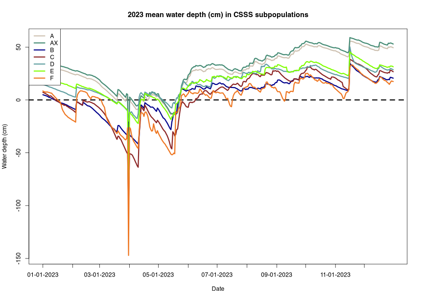
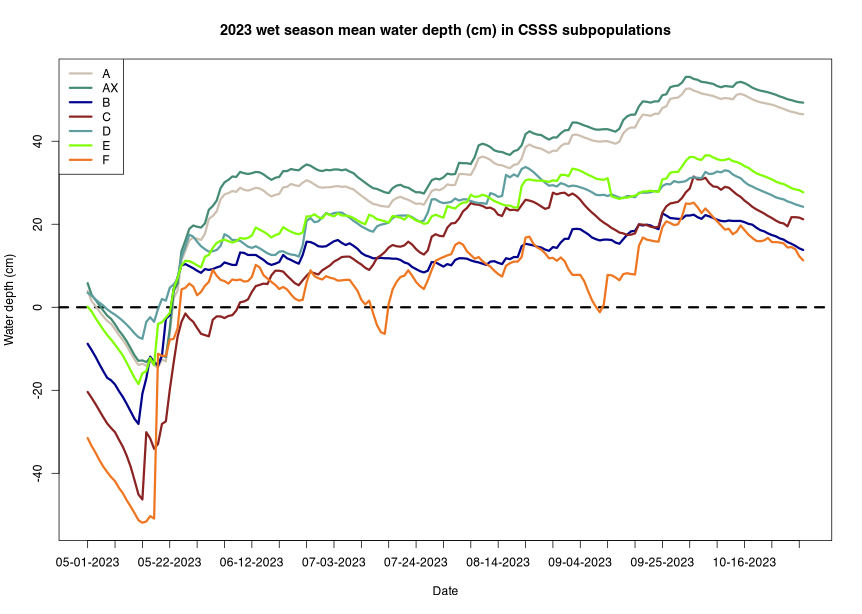
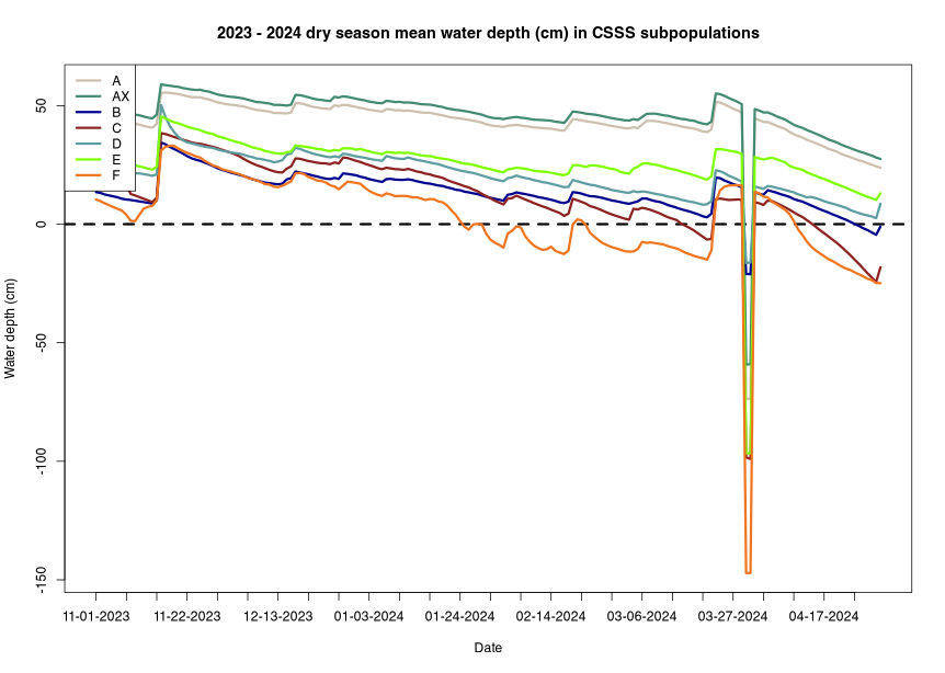
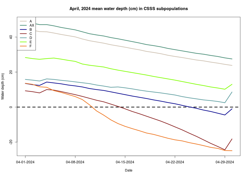
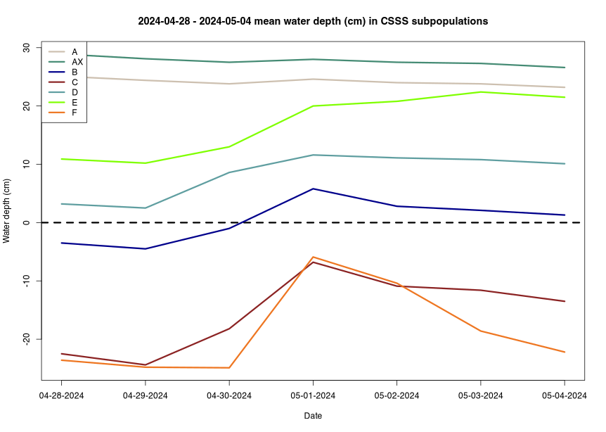
The CSSS Water-Depth Maps contain daily water depth based on the daily EDEN water-level surfaces, which are generated each day using water-level gage data, and ground elevation data. Water-depth values are displayed in both centimeters and inches (relative to North American Vertical Datum of 1988 (NAVD 88)). The data is served using the same 400 meters by 400 meters grid as other EDEN data. See details below ("Quality water-level data used to generate the daily water-level surfaces") about the daily water-level surfaces based on the quality of the water-level gage data.
From the Water-Depth Map tab:


| For 2024-04-25 | ||
| ≥40% dry | DHP | |
| AX | 0 days | 112 days |
| A | 0 days | 112 days |
| A1 | 0 days | 112 days |
| A2 | 0 days | 112 days |
| B | 13 days | 99 days |
| C | 18 days | 94 days |
| D | 0 days | 112 days |
| E | 0 days | 112 days |
| F | 34 days | 43 days |
Summary statistics for the Cape Sable seaside sparrow subpopulation areas, showing percent of subpopulation areas dry during nesting season (March 1 through July 15) for at least 40 and 90 consecutive days; percent of subpopulation areas with discontinuous hydroperiods during the calendar year of 0 to 89, 90 to 210, and > 210 days; and mean four-year hydroperiod and standard deviation. A CSV file of these statistics used in this application can be downloaded here.
New: Popup statistics graphs now available; click column headings (e.g., "≥ 40") to view.
| A Nesting | AX Nesting | B Nesting | C Nesting | D Nesting | E Nesting | F Nesting | ||||||||
|---|---|---|---|---|---|---|---|---|---|---|---|---|---|---|
| Year | ≥ 40 | ≥ 90 |
≥ 40 | ≥ 90 |
≥ 40 | ≥ 90 |
≥ 40 | ≥ 90 |
≥ 40 | ≥ 90 |
≥ 40 | ≥ 90 |
≥ 40 | ≥ 90 |
| 1991 | 87.4% | 0% | 90.1% | 1.4% | 100% | 32.3% | 100% | 82.6% | 97.2% | 19.5% | 100% | 27.9% | 100% | 78.8% |
| 1992 | 56.3% | 25.9% | 65.7% | 41% | 95.2% | 90.7% | 100% | 100% | 97.6% | 80.9% | 100% | 99.1% | 100% | 100% |
| 1993 | 2.9% | 0.2% | 5.7% | 0.4% | 78.1% | 60.1% | 98.7% | 97.5% | 72.8% | 58.5% | 91.8% | 62.4% | 100% | 100% |
| 1994 | 22.9% | 3.1% | 34.2% | 8% | 94.6% | 73% | 96.2% | 82.2% | 56.5% | 22.8% | 99.7% | 70.2% | 100% | 100% |
| 1995 | 0% | 0% | 0% | 0% | 70.4% | 44.7% | 98.7% | 89.8% | 58.1% | 20.3% | 46.2% | 19.1% | 100% | 99.3% |
| 1996 | 21.5% | 2.3% | 37.1% | 9.8% | 79.1% | 42% | 100% | 43.2% | 88.2% | 34.1% | 82% | 48.9% | 100% | 86.8% |
| 1997 | 22.5% | 10.5% | 34.3% | 21.4% | 86.5% | 55.1% | 100% | 81.4% | 94.3% | 70.7% | 98.6% | 35.4% | 100% | 100% |
| 1998 | 27.2% | 5.6% | 38.2% | 8.6% | 87.5% | 47.5% | 98.3% | 95.3% | 58.1% | 17.5% | 95.8% | 44.7% | 100% | 100% |
| 1999 | 37.3% | 8% | 50.8% | 15.2% | 100% | 71% | 100% | 100% | 100% | 72% | 100% | 79.6% | 100% | 100% |
| 2000 | 31.6% | 12.8% | 46.3% | 21.4% | 90.2% | 73.4% | 100% | 93.6% | 80.1% | 50.4% | 97.2% | 64.6% | 100% | 100% |
| 2001 | 84.2% | 40.2% | 87.6% | 53% | 100% | 99.9% | 100% | 100% | 100% | 89.8% | 100% | 99.4% | 100% | 100% |
| 2002 | 72.9% | 26.5% | 78.7% | 42.3% | 99.7% | 62.3% | 100% | 100% | 100% | 71.1% | 98.9% | 58.8% | 100% | 100% |
| 2003 | 38.5% | 1.8% | 51.7% | 6.1% | 41.2% | 25.5% | 96.6% | 51.3% | 34.6% | 24% | 64.3% | 23.2% | 100% | 7.3% |
| 2004 | 52.5% | 31.2% | 62.7% | 46% | 100% | 92.9% | 100% | 100% | 98.4% | 85% | 100% | 89.3% | 100% | 100% |
| 2005 | 57.4% | 25.9% | 66.6% | 41.3% | 99.7% | 80.7% | 100% | 100% | 78.9% | 62.2% | 100% | 92.9% | 100% | 100% |
| 2006 | 55.7% | 34.3% | 65.2% | 48.4% | 98.5% | 44.4% | 100% | 92.8% | 85.8% | 63% | 100% | 63.2% | 100% | 100% |
| 2007 | 28.6% | 5.6% | 44% | 16% | 90.4% | 36.1% | 100% | 93.6% | 71.5% | 22.8% | 97.8% | 36.5% | 100% | 100% |
| 2008 | 63.3% | 24% | 71.2% | 38.4% | 100% | 70.9% | 100% | 99.2% | 93.9% | 31.7% | 100% | 73.4% | 100% | 100% |
| 2009 | 73.4% | 15.8% | 79.1% | 32.1% | 100% | 65.9% | 100% | 83.5% | 100% | 27.2% | 100% | 16.6% | 100% | 100% |
| 2010 | 31.5% | 11.2% | 45.7% | 19.3% | 77.9% | 58.4% | 100% | 94.1% | 56.1% | 32.5% | 84.6% | 65% | 100% | 58.9% |
| 2011 | 73.9% | 60.8% | 79.5% | 69.2% | 100% | 99.1% | 100% | 100% | 100% | 93.5% | 100% | 100% | 100% | 100% |
| 2012 | 55.2% | 11.5% | 64.9% | 20.8% | 98.3% | 23.4% | 100% | 6.4% | 82.9% | 0.8% | 99.4% | 8.2% | 100% | 36.4% |
| 2013 | 37.2% | 0.9% | 50.7% | 2.4% | 74.9% | 13.4% | 100% | 7.2% | 65.9% | 2% | 93.4% | 0.2% | 100% | 100% |
| 2014 | 67.1% | 23.1% | 74.2% | 36.1% | 94.9% | 68.6% | 100% | 100% | 91.1% | 55.7% | 99.2% | 74.1% | 100% | 100% |
| 2015 | 48.1% | 33.6% | 59.3% | 47.9% | 96% | 30.8% | 100% | 97.5% | 87.8% | 6.5% | 100% | 45.1% | 100% | 100% |
| 2016 | 10.7% | 4.4% | 14.1% | 5.7% | 69.6% | 32.9% | 46.6% | 3% | 11% | 3.7% | 19.4% | 6% | 2.6% | 0% |
| 2017 | 52.7% | 32.7% | 62.8% | 47.2% | 79.8% | 69.5% | 100% | 100% | 76% | 62.6% | 92.3% | 79% | 100% | 100% |
| 2018 | 47.1% | 0.6% | 58.4% | 1.5% | 78.7% | 18.4% | 100% | 12.3% | 77.2% | 5.7% | 85.6% | 5.5% | 100% | 78.8% |
| 2019 | 31% | 19.2% | 45.8% | 34.1% | 62.6% | 55.5% | 100% | 100% | 61.4% | 41.1% | 87.6% | 79.9% | 100% | 100% |
| 2020 | 67.9% | 24% | 74.8% | 35.4% | 87.3% | 24.5% | 100% | 16.1% | 80.5% | 14.2% | 100% | 26.5% | 100% | 10.6% |
| 2021 | 62.1% | 28.6% | 69.9% | 36.9% | 79.8% | 41.2% | 100% | 25.8% | 72% | 30.9% | 79.8% | 27% | 100% | 87.4% |
| 2022 | 23.4% | 9.7% | 30.9% | 13.8% | 45.9% | 34.5% | 97% | 19.1% | 43.9% | 11% | 32.6% | 7.1% | 100% | 43% |
| 2023 | 29.4% | 1.2% | 37.3% | 3.6% | 79.4% | 17.2% | 94.1% | 54.7% | 38.6% | 2.4% | 41.5% | 14.9% | 97.4% | 9.3% |
| A Annual | AX Annual | B Annual | C Annual | D Annual | E Annual | F Annual | |||||||||||||||
|---|---|---|---|---|---|---|---|---|---|---|---|---|---|---|---|---|---|---|---|---|---|
| Year | 0 to 89 | 90 to 210 | ≥ 211 |
0 to 89 | 90 to 210 | ≥ 211 |
0 to 89 | 90 to 210 | ≥ 211 |
0 to 89 | 90 to 210 | ≥ 211 |
0 to 89 | 90 to 210 | ≥ 211 |
0 to 89 | 90 to 210 | ≥ 211 |
0 to 89 | 90 to 210 | ≥ 211 |
| 1991 | 0% | 11.6% | 88.4% | 0% | 24.8% | 75.2% | 27.4% | 50.7% | 21.9% | 91.9% | 8.1% | 0% | 12.6% | 57.7% | 29.7% | 35.7% | 59.4% | 4.9% | 94.7% | 5.3% | 0% |
| 1992 | 0% | 22.6% | 77.4% | 0% | 38.4% | 61.6% | 26.8% | 56.9% | 16.4% | 91.5% | 8.5% | 0% | 32.9% | 44.3% | 22.8% | 32.6% | 67.2% | 0.2% | 100% | 0% | 0% |
| 1993 | 0% | 0.2% | 99.8% | 0% | 0.6% | 99.4% | 34.8% | 26.9% | 38.3% | 44.1% | 54.7% | 1.3% | 8.5% | 52.4% | 39% | 31.2% | 34.5% | 34.3% | 92.7% | 7.3% | 0% |
| 1994 | 0% | 2.1% | 97.9% | 0% | 6.9% | 93.1% | 20.9% | 52.2% | 26.9% | 16.1% | 80.1% | 3.8% | 3.7% | 51.6% | 44.7% | 4.9% | 75.4% | 19.7% | 68.2% | 31.8% | 0% |
| 1995 | 0% | 0% | 100% | 0% | 0% | 100% | 6.4% | 31.2% | 62.4% | 8.5% | 50% | 41.5% | 0% | 5.7% | 94.3% | 0% | 5.5% | 94.5% | 49.7% | 27.2% | 23.2% |
| 1996 | 0% | 0.1% | 99.9% | 0% | 0.2% | 99.8% | 32.8% | 27% | 40.1% | 57.2% | 41.5% | 1.3% | 5.7% | 52.4% | 41.9% | 17.4% | 26.3% | 56.3% | 88.7% | 11.3% | 0% |
| 1997 | 0% | 2.8% | 97.2% | 0% | 6% | 94% | 18.7% | 30.8% | 50.5% | 14.4% | 85.6% | 0% | 3.7% | 54.9% | 41.5% | 7.4% | 28.2% | 64.4% | 88.7% | 11.3% | 0% |
| 1998 | 0% | 0.7% | 99.3% | 0% | 2.2% | 97.8% | 25.1% | 13.8% | 61.1% | 59.3% | 33.1% | 7.6% | 6.5% | 19.9% | 73.6% | 14.6% | 16.5% | 69% | 94.7% | 5.3% | 0% |
| 1999 | 0% | 0.1% | 99.9% | 0% | 0.2% | 99.8% | 24.5% | 22.1% | 53.4% | 8.5% | 80.1% | 11.4% | 2.8% | 29.3% | 67.9% | 2.7% | 31% | 66.3% | 55% | 44.4% | 0.7% |
| 2000 | 0.8% | 7.6% | 91.6% | 1.3% | 14.5% | 84.2% | 32.7% | 27.7% | 39.6% | 8.1% | 91.9% | 0% | 4.1% | 45.9% | 50% | 19.4% | 29.3% | 51.3% | 94.7% | 5.3% | 0% |
| 2001 | 0% | 26.1% | 73.9% | 0% | 41.7% | 58.3% | 25.2% | 63.8% | 11% | 8.1% | 91.9% | 0% | 3.7% | 78.5% | 17.9% | 13.9% | 80.1% | 6% | 83.4% | 16.6% | 0% |
| 2002 | 0% | 6% | 94% | 0% | 11.2% | 88.8% | 26.7% | 29.7% | 43.6% | 23.3% | 76.7% | 0% | 9.3% | 52.4% | 38.2% | 13.2% | 25.1% | 61.8% | 84.1% | 15.9% | 0% |
| 2003 | 0% | 6.1% | 93.9% | 0% | 10% | 90% | 21.3% | 25.2% | 53.5% | 8.9% | 80.1% | 11% | 4.1% | 41.9% | 54.1% | 6.3% | 25.2% | 68.5% | 6% | 66.9% | 27.2% |
| 2004 | 0% | 4.4% | 95.6% | 0% | 9.3% | 90.7% | 36% | 34.2% | 29.7% | 41.1% | 58.9% | 0% | 31.3% | 31.3% | 37.4% | 19.9% | 32.3% | 47.8% | 88.1% | 11.9% | 0% |
| 2005 | 0% | 5.7% | 94.3% | 0% | 12.3% | 87.7% | 23.3% | 58.1% | 18.6% | 2.5% | 96.6% | 0.8% | 2.8% | 59.3% | 37.8% | 3% | 58.3% | 38.7% | 3.3% | 96.7% | 0% |
| 2006 | 0% | 8% | 92% | 0% | 13.1% | 86.9% | 29.1% | 47.2% | 23.7% | 85.2% | 14.8% | 0% | 25.6% | 45.5% | 28.9% | 29.6% | 32.3% | 38.1% | 100% | 0% | 0% |
| 2007 | 5.5% | 16.9% | 77.6% | 12.6% | 25.1% | 62.3% | 29.3% | 40.9% | 29.8% | 64.8% | 35.2% | 0% | 5.3% | 58.9% | 35.8% | 37.3% | 33.4% | 29.3% | 100% | 0% | 0% |
| 2008 | 0% | 36.8% | 63.2% | 0% | 50.4% | 49.6% | 29.5% | 55.9% | 14.6% | 3.4% | 96.6% | 0% | 3.7% | 73.2% | 23.2% | 1.6% | 96.1% | 2.4% | 15.9% | 84.1% | 0% |
| 2009 | 0.2% | 6.6% | 93.2% | 0.4% | 12.7% | 86.9% | 23.3% | 33.2% | 43.5% | 2.5% | 62.7% | 34.7% | 3.7% | 26.4% | 69.9% | 5.2% | 24.3% | 70.5% | 49.7% | 50.3% | 0% |
| 2010 | 0% | 14.8% | 85.2% | 0% | 23.3% | 76.7% | 27.2% | 26.7% | 46.1% | 10.2% | 89% | 0.8% | 3.3% | 38.2% | 58.5% | 10.2% | 38.6% | 51.3% | 18.5% | 81.5% | 0% |
| 2011 | 2.9% | 21.5% | 75.7% | 7.8% | 30.4% | 61.8% | 32.3% | 42.1% | 25.6% | 30.9% | 69.1% | 0% | 13.8% | 56.1% | 30.1% | 27.1% | 58% | 14.9% | 95.4% | 4.6% | 0% |
| 2012 | 0% | 7.5% | 92.5% | 0% | 12.9% | 87.1% | 17.9% | 20% | 62.1% | 0.8% | 23.3% | 75.8% | 0.4% | 6.5% | 93.1% | 0.2% | 17.2% | 82.6% | 0.7% | 73.5% | 25.8% |
| 2013 | 0% | 3.7% | 96.3% | 0% | 7% | 93% | 20.8% | 20.8% | 58.5% | 1.7% | 56.4% | 41.9% | 2% | 23.2% | 74.8% | 1.4% | 17.4% | 81.2% | 2% | 91.4% | 6.6% |
| 2014 | 1.2% | 9% | 89.8% | 2% | 16.6% | 81.4% | 39.9% | 16.8% | 43.3% | 37.7% | 58.5% | 3.8% | 5.7% | 25.2% | 69.1% | 24.6% | 21.5% | 53.9% | 74.2% | 25.8% | 0% |
| 2015 | 6.3% | 25.3% | 68.5% | 12.2% | 34% | 53.8% | 31.3% | 42.2% | 26.5% | 79.7% | 20.3% | 0% | 14.6% | 50.4% | 35% | 34.3% | 51.3% | 14.4% | 100% | 0% | 0% |
| 2016 | 0% | 2.1% | 97.9% | 0% | 3.5% | 96.5% | 18.3% | 17.9% | 63.8% | 0.8% | 8.1% | 91.1% | 0.4% | 3.3% | 96.3% | 0% | 6.7% | 93.3% | 0% | 28.5% | 71.5% |
| 2017 | 0% | 9.8% | 90.2% | 0% | 17% | 83% | 9.4% | 43.7% | 47% | 0.4% | 96.6% | 3% | 0% | 30.9% | 69.1% | 0% | 42.5% | 57.5% | 0% | 100% | 0% |
| 2018 | 0% | 9.4% | 90.6% | 0% | 12.9% | 87.1% | 18.6% | 17.3% | 64.1% | 2.5% | 19.1% | 78.4% | 1.6% | 2.8% | 95.5% | 0.3% | 7.1% | 92.6% | 10.6% | 77.5% | 11.9% |
| 2019 | 5.9% | 9.7% | 84.4% | 10% | 16.1% | 73.9% | 22.9% | 26.6% | 50.5% | 14% | 55.9% | 30.1% | 2.8% | 24.8% | 72.4% | 10% | 29% | 61% | 49% | 51% | 0% |
| 2020 | 0% | 18.5% | 81.5% | 0% | 27.3% | 72.7% | 7.4% | 33% | 59.6% | 0.4% | 33.9% | 65.7% | 0% | 8.5% | 91.5% | 0% | 24.1% | 75.9% | 0% | 86.1% | 13.9% |
| 2021 | 2.6% | 8.3% | 89.1% | 4.1% | 11.3% | 84.6% | 17.9% | 14.7% | 67.4% | 0.8% | 14% | 85.2% | 0% | 3.7% | 96.3% | 0% | 16.1% | 83.9% | 0% | 68.2% | 31.8% |
| 2022 | 0.1% | 7.2% | 92.8% | 0% | 10.9% | 89.1% | 18.9% | 20.8% | 60.3% | 2.5% | 17.8% | 79.7% | 2% | 1.6% | 96.3% | 0.8% | 6.9% | 92.3% | 23.2% | 43.7% | 33.1% |
| 2023 | 0% | 2.3% | 97.7% | 0% | 4.1% | 95.9% | 10.9% | 16.2% | 73% | 0.8% | 26.7% | 72.5% | 0% | 4.5% | 95.5% | 0% | 8.5% | 91.5% | 2.6% | 19.2% | 78.1% |
| A | AX | B | C | D | E | F | |||||||||||||||
|---|---|---|---|---|---|---|---|---|---|---|---|---|---|---|---|---|---|---|---|---|---|
| Year | Mean 4YHP | Mean 4YHP % | Mean 4YHP SD |
Mean 4YHP | Mean 4YHP % | Mean 4YHP SD |
Mean 4YHP | Mean 4YHP % | Mean 4YHP SD |
Mean 4YHP | Mean 4YHP % | Mean 4YHP SD |
Mean 4YHP | Mean 4YHP % | Mean 4YHP SD |
Mean 4YHP | Mean 4YHP % | Mean 4YHP SD |
Mean 4YHP | Mean 4YHP % | Mean 4YHP SD |
| 1995 | 298 days | 2% | 57 days | 285 days | 6% | 59 days | 153 days | 42% | 28 days | 72 days | 25% | 49 days | 188 days | 53% | 44 days | 138 days | 52% | 36 days | 29 days | 6% | 25 days |
| 1996 | 329 days | 0% | 45 days | 319 days | 1% | 53 days | 178 days | 38% | 49 days | 112 days | 71% | 66 days | 218 days | 50% | 64 days | 185 days | 57% | 88 days | 53 days | 24% | 46 days |
| 1997 | 348 days | 0% | 17 days | 339 days | 0% | 25 days | 185 days | 34% | 44 days | 126 days | 74% | 47 days | 234 days | 42% | 44 days | 208 days | 41% | 76 days | 57 days | 26% | 43 days |
| 1998 | 342 days | 0% | 20 days | 331 days | 0% | 28 days | 191 days | 37% | 41 days | 136 days | 82% | 44 days | 234 days | 37% | 44 days | 220 days | 33% | 69 days | 59 days | 29% | 41 days |
| 1999 | 343 days | 0% | 18 days | 332 days | 0% | 25 days | 200 days | 25% | 37 days | 127 days | 75% | 50 days | 242 days | 28% | 47 days | 237 days | 22% | 55 days | 48 days | 20% | 43 days |
| 2000 | 333 days | 0% | 12 days | 320 days | 0% | 14 days | 188 days | 24% | 27 days | 118 days | 73% | 35 days | 226 days | 34% | 33 days | 216 days | 24% | 28 days | 41 days | 12% | 30 days |
| 2001 | 327 days | 2% | 14 days | 312 days | 6% | 19 days | 185 days | 26% | 27 days | 133 days | 83% | 34 days | 231 days | 33% | 33 days | 212 days | 27% | 30 days | 42 days | 11% | 32 days |
| 2002 | 308 days | 4% | 39 days | 292 days | 9% | 43 days | 172 days | 28% | 38 days | 134 days | 84% | 34 days | 220 days | 42% | 48 days | 199 days | 31% | 44 days | 50 days | 13% | 34 days |
| 2003 | 297 days | 6% | 36 days | 280 days | 13% | 39 days | 166 days | 32% | 32 days | 140 days | 91% | 21 days | 200 days | 52% | 40 days | 196 days | 35% | 39 days | 57 days | 17% | 29 days |
| 2004 | 292 days | 9% | 31 days | 273 days | 17% | 32 days | 170 days | 32% | 35 days | 142 days | 89% | 22 days | 196 days | 52% | 33 days | 194 days | 36% | 38 days | 80 days | 34% | 68 days |
| 2005 | 286 days | 8% | 24 days | 269 days | 16% | 24 days | 162 days | 35% | 38 days | 130 days | 84% | 27 days | 177 days | 50% | 36 days | 189 days | 38% | 37 days | 84 days | 44% | 64 days |
| 2006 | 295 days | 6% | 11 days | 279 days | 11% | 10 days | 168 days | 34% | 36 days | 139 days | 86% | 35 days | 186 days | 49% | 33 days | 200 days | 33% | 30 days | 113 days | 78% | 76 days |
| 2007 | 297 days | 6% | 12 days | 281 days | 11% | 12 days | 160 days | 41% | 37 days | 126 days | 85% | 52 days | 180 days | 51% | 38 days | 188 days | 44% | 35 days | 106 days | 76% | 86 days |
| 2008 | 294 days | 11% | 22 days | 273 days | 21% | 29 days | 148 days | 45% | 24 days | 104 days | 69% | 52 days | 175 days | 54% | 34 days | 169 days | 44% | 36 days | 63 days | 9% | 80 days |
| 2009 | 285 days | 16% | 31 days | 263 days | 27% | 35 days | 147 days | 48% | 26 days | 110 days | 81% | 53 days | 183 days | 63% | 28 days | 168 days | 53% | 40 days | 78 days | 17% | 82 days |
| 2010 | 285 days | 13% | 32 days | 263 days | 23% | 37 days | 151 days | 47% | 29 days | 112 days | 82% | 56 days | 190 days | 59% | 38 days | 174 days | 48% | 47 days | 56 days | 9% | 58 days |
| 2011 | 288 days | 16% | 35 days | 264 days | 27% | 38 days | 160 days | 37% | 34 days | 129 days | 87% | 49 days | 211 days | 47% | 41 days | 186 days | 45% | 47 days | 82 days | 45% | 58 days |
| 2012 | 276 days | 16% | 36 days | 257 days | 26% | 37 days | 154 days | 38% | 34 days | 137 days | 91% | 36 days | 203 days | 47% | 45 days | 185 days | 46% | 45 days | 90 days | 53% | 44 days |
| 2013 | 288 days | 11% | 33 days | 269 days | 20% | 34 days | 171 days | 32% | 34 days | 160 days | 96% | 51 days | 224 days | 39% | 49 days | 204 days | 42% | 50 days | 109 days | 66% | 66 days |
| 2014 | 297 days | 10% | 38 days | 278 days | 18% | 40 days | 179 days | 30% | 37 days | 162 days | 95% | 53 days | 232 days | 39% | 50 days | 211 days | 41% | 54 days | 127 days | 85% | 66 days |
| 2015 | 293 days | 9% | 34 days | 274 days | 17% | 38 days | 172 days | 28% | 41 days | 154 days | 90% | 61 days | 229 days | 34% | 47 days | 204 days | 36% | 58 days | 112 days | 73% | 74 days |
| 2016 | 295 days | 12% | 31 days | 273 days | 20% | 39 days | 175 days | 28% | 37 days | 145 days | 92% | 74 days | 233 days | 35% | 42 days | 203 days | 39% | 61 days | 109 days | 73% | 78 days |
| 2017 | 306 days | 8% | 42 days | 287 days | 13% | 53 days | 184 days | 24% | 44 days | 163 days | 83% | 101 days | 252 days | 24% | 67 days | 225 days | 30% | 90 days | 128 days | 76% | 107 days |
| 2018 | 298 days | 10% | 41 days | 279 days | 16% | 52 days | 186 days | 29% | 51 days | 161 days | 89% | 101 days | 248 days | 26% | 68 days | 217 days | 36% | 91 days | 121 days | 74% | 106 days |
| 2019 | 301 days | 10% | 41 days | 284 days | 14% | 52 days | 204 days | 25% | 46 days | 196 days | 54% | 99 days | 263 days | 17% | 68 days | 242 days | 23% | 89 days | 142 days | 93% | 99 days |
| 2020 | 312 days | 8% | 32 days | 296 days | 13% | 40 days | 218 days | 22% | 31 days | 221 days | 35% | 61 days | 282 days | 8% | 45 days | 263 days | 17% | 60 days | 159 days | 87% | 75 days |
| 2021 | 295 days | 14% | 22 days | 276 days | 21% | 26 days | 215 days | 25% | 29 days | 207 days | 46% | 45 days | 268 days | 17% | 28 days | 241 days | 26% | 37 days | 140 days | 97% | 42 days |
| 2022 | 295 days | 13% | 20 days | 276 days | 20% | 24 days | 218 days | 21% | 24 days | 220 days | 39% | 40 days | 279 days | 12% | 20 days | 254 days | 22% | 33 days | 154 days | 94% | 45 days |
| 2023 | 300 days | 12% | 27 days | 282 days | 18% | 33 days | 222 days | 22% | 30 days | 222 days | 32% | 43 days | 284 days | 7% | 28 days | 263 days | 19% | 48 days | 158 days | 81% | 54 days |
| 2024 | 307 days | 8% | 27 days | 293 days | 12% | 32 days | 229 days | 22% | 28 days | 240 days | 21% | 21 days | 296 days | 4% | 19 days | 285 days | 12% | 37 days | 192 days | 62% | 46 days |