
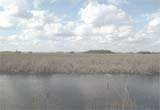
Everglades Depth Estimation Network (EDEN) for Support of Biological and Ecological Assessments
EDENapps is a series of independent EDEN tools that assist users in using the EDEN spatial data layers. These tools interface with the EDEN water surfaces and EDENapps DEM. Please note that these tools were developed initally developed for 32-bit systems; however, most tools do have a 64-bit version available.
| Tool | Purpose | Screenshot |
|---|---|---|
| DataViewer | Displays EDEN data layers including panning, zooming, and animation of multiple dates of water surface, depth, and days since dry; queries of data values, and generation of time-series graphs. | 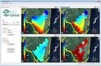 |
| xyLocator | Returns values from EDEN data layers at specific x,y coordinates over a specified time period. Users can input a file with a list of sample site locations. | 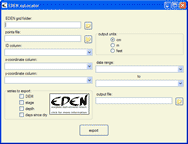 |
| TransectPlotter | Select a point-to-point transect (not necessarily a straight line) and plots EDEN data profile over the time series, includes animation, plotting of observer data, and ground slope. | 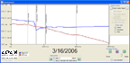 |
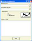
| Depth&DaysSinceDry | EDEN Depth&DaysSinceDry is a program for creating daily surfaces (in NetCDF file format, .nc) of water depth and days since dry from EDEN daily water level surfaces and ground elevation model. |
 |
| Download EDEN DEM file for ground elevation for use in the tools above. Please note: This file is intended specifically for use in the EDEN applications software as elevation values have been converted from meters (m) to centimeters (cm) for use by EDEN applications software. | ||
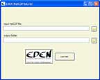
| NetCDFtoGrid | EDEN NetCDFtoGrid is a program for converting EDEN water level, water depth, and days since dry files from EDEN NetCDF files to ESRI Grid files. |
 |
| GridtoNetCDF | The EDEN GridtoNetCDF is no longer available. Please contact Heather Henkel (hhenkel@usgs.gov) with questions regarding this tool. |
|