|
You will need the following files:
(Note: if you previously installed other EDENapp tools, then you may have some or all of these items already installed)
- NetCDFtoGrid.exe (.zip, currently at v. 1.0, 180 KB)
- NetCDFtoGrid can be copied to any location on your computer
- Runs only on 32-bit systems. For users with 64-bit machines, please use the Multidimension Tools toolbox found within ArcMap to convert NetCDF files.
- NetCDF dlls (.zip, 176 KB)
- Extract all the files in netcdf-3.6.1-win32.zip and copy them to c:\windows\system32
- Microsoft .Net version 2.0 (download from Microsoft's website)
- Note: this may already be installed on your machine. Go to: Start > Control Panel > Add or Remove Programs. If Microsoft .Net Framework is installed, it will appear in this list
- ArcGIS (v. 9.1 or later)
To Use:
(Please note: there is no user's guide for this tool. Full instructions are below.)
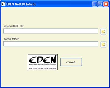
- Click on the first folder icon
 to browse to the folder containing the NetCDF files to browse to the folder containing the NetCDF files
- Click on the second folder icon to browse to the folder where you would like to save the output file. Type in an output name.
- If the output file already exists, select:
- Add new dates to existing files or
- Overwrite duplicate dates in existing file
- Click the "Convert" button
Files that can be converted with this program:
- EDEN daily water level surfaces
- NetCDF format file(s) (.nc) containing daily water level surfaces
- Multiple one-quarter-year files can be used for requested time series (be sure that continuous data files are present for accurate time series calculations)
- Available for download at http://sofia.usgs.gov/eden/models/watersurfacemod.php.
- EDEN daily water depth
- NetCDF format file(s) (.nc) containing daily water depth
- Multiple one-quarter-year files can be used for requested time series (be sure that continuous data files are present for accurate time series calculations)
- Can be derived from EDEN daily water level surfaces and ground elevation surface using the EDEN Depth&DaysSinceDry Tool, available for download at http://sofia.usgs.gov/eden/edenapps/index.php
- EDEN days since dry
- NetCDF format file(s) (.nc) containing days since dry
- Multiple one-quarter-year files can be used for requested time series (be sure that continuous data files are present for accurate time series calculations)
- Can be derived from EDEN daily water level surfaces and ground elevation surface using the EDEN Depth&DaysSinceDry Tool, available for download at http://sofia.usgs.gov/eden/edenapps/index.php
|