The Journey to Restore America's Everglades - Recover Home Page
National Park Service Home Page South Florida Water Management District Home Page U.S. Army Corps of Engineers Home Page U.S. Geological Survey Home Page
Everglades Depth Estimation Network (EDEN) for Support of Biological and Ecological Assessments
Data
Gage Water Levels
EDENapps
Information
Photo of a mangrove fringe

Gage Data for EDEN Network

Search by Area
map showing areas within south Florida

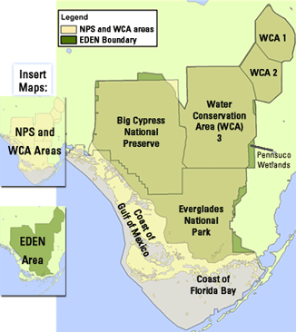
WCA1 | WCA2 | WCA3 | Big Cypress National Preserve | Everglades National Park | Pennsuco Wetlands | Coast of Florida Bay | Coast of Gulf of Mexico

(full station list below)

Gages by Name

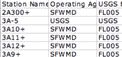
Access stations quickly by name: 2A300, 3A-5, 3A9, BARW4, EDEN_7, and more. A full list is below...

Search by Bounding Coordinates
Latitude:
From:
To:

Enter a latitude range from 25 to 27 degrees north.

Longitude:
From:
To:

Enter a longitude range from 80 to 82 degrees west.

Download Station Information

screenshot of an excel fileDownload metadata information about stations including Latitude, Longitude, datum, vegetation, more.... This new feature allows you to download the data from our database directly into a tab-delineated text format.

Google Earth (KML) - View EDEN Stations

screenshot of a Google Earth showing eden gage locationsA Google Earth file (.kml) is available for those users who wish to view EDEN gages in Google Earth. Download the EDEN (.kml) file.

Station Listing
[ 0 1 | 2 | 3 | 4 | 5 | 6 | 7 | 8 | 9 | A | B | C | D | E | F | G | H | I | J | K | L | M | N | O | P | Q | R | S | T | U | V | W | X | Y | Z ]
2A300
3A-5
3A9
3A10
3A11
3A12
3AN1W1
3AN1_GW4
3ANE
3ANE_GW
3ANW
3ANW_GW
3AS
3AS3W1
3AS3_GW
3ASW
3B-SE
3BS1W1
3BS1_GW2
A13
Alligator_Creek
ANGEL
Barron_River
BARW4
BARW6A
BCA1
BCA2
BCA3
BCA4
BCA5
BCA6 (now Tamiami_Canal_40-Mile_Bend_to_Monroe)
BCA7 (now Tamiami_Canal_Monroe_to_Carnestown)
BCA8
BCA9
BCA10
BCA11
BCA12
BCA13
BCA14
BCA15
BCA16
BCA17
BCA18
BCA19
BCA20
Bottle_Creek_at_Rookery_Branch
BR
Broad_River_near_the_Cutoff
BSC
C111_wetland_east_of_FIU_LTER_TSPH5
CH1 (now MO-216)
Chatham_River_near_the_Watson_Place
CN
CP
CR2
CR3
CT27R
CT50R
CV5NR
CY2
CY3
DO1
DO2
E112
E146
East_Side_Creek
EDEN_1
EDEN_3
EDEN_4
EDEN_5
EDEN_6
EDEN_7
EDEN_8
EDEN_9
EDEN_10
EDEN_11
EDEN_12
EDEN_13
EDEN_14
EP1R
EPSW
EVER4
EVER5A
EVER5B
EVER6
EVER7
EVER8
G-596
G-620
G-975
G-1251
G-1488
G-1502
G-3272
G-3273
G-3437
G-3567
G-3574
G-3575
G-3576
G-3577
G-3578
G-3626
G-3628
G-3676
G-3761
G-3777
G-3818
G119_H
G119_T
G211_H
G211_T
G251_T
G300_T
G301_T
G338_T
G339_H
G339_T
G737_T
Harney_River
Joe_Bay_2E
L28S1
L28S2
L28_GAP
L28_GAPG1
L31NN
L31NS
L31N_1
L31N_3
L31N_4
L31N_5
L31N_7
L31W
LO1 (now MO-214)
LO2
LO3
LOOP1_H
LOOP1_T
LOOP2_H
LOOP2_T
Lopez_River_Near_Lopez_Campsite
Lostmans_River_below_Second_Bay
Manatee_Bay_Creek
McCormick_Creek_at_mouth
MET-1
MO-214 (formerly LO1)
MO-215 (formerly SH1)
MO-216 (formerly CH1)
Mud_Creek_at_mouth
NCL
NESRS1
NESRS2
NESRS3
NESRS4
NESRS5
New_River_at_Sunday_Bay
NMP
NORTH_CA1
North_River_Upstream_of_Cutoff
NP44
NP46
NP62
NP67
NP72
NP201
NP202
NP203
NP205
NP206
NR
NTS1
NTS10
NTS14
NTS18
NWWF
OKAL29
OL
OT
P33
P34
P35
P36
P37
P38
R127
R3110
Raulerson_Brothers_Canal
RG1
RG2
RG3
S7_T
S8_T
S9A_T
S10A_H
S10A_T
S10C_H
S10C_T
S10D_H
S10D_T
S11A_H
S11A_T
S11B_H
S11B_T
S11C_H
S11C_T
S12A_H
S12A_T
S12B_H
S12B_T
S12C_H
S12C_T
S12D_H
S12D_T
S18C_T
S31_H
S34E_H
S34_H
S39_H
S140_H
S140_T
S141_H
S141_T
S142_H
S142_T
S143_T
S144_H
S144_T
S145_H
S145_T
S146_H
S146_T
S150_T
S151_H
S151_T
S175_H
S175_T
S190_H
S190_T
S332B_T
S332D_T
S332_T
S333_H
S333_T
S334_H
S334_T
S335_H
S335_T
S336_H
S336_T
S337_T
S339_H
S339_T
S340_H
S340_T
S343A_H
S343A_T
S343B_H
S343B_T
S344_H
S344_T
S380_H
SH1 (now MO-215)
SH2
SH3
SH4
SH5
Shark_River_Below_Gunboat_Island
SITE_7
SITE_8C
SITE_8T
SITE_9
SITE_17
SITE_19
SITE_62
SITE_63
SITE_64
SITE_65
SITE_69E
SITE_69W
SITE_71
SITE_76
SITE_99
SOUTH_CA1
SP
SPARO
SR1
SRS1
Stillwater_Creek
Tamiami_Canal_40-Mile_Bend_to_Monroe (formerly BCA6)
Tamiami_Canal_Monroe_to_Carnestown (formerly BCA7)
Taylor_River_at_mouth
Taylor_Slough_wetland_at_E146
TE
TI-8
TI-9
TMC
Trout_Creek_at_mouth
TS2
TSB
TSH
Turner_River_nr_Chokoloskee_Island
Upstream_Broad_River
Upstream_Lostmans_River
Upstream_North_River
Upstream_Taylor_River
USSO_O
USSO_T
W2
W5
W11
W14
W15
W18
WC2A159
WC2AN1
WC2AS1
WCA1ME
WCA2E1
WCA2E4
WCA2F1
WCA2F4
WCA2RT
WCA2U1
WCA2U3
West_Highway_Creek
WFEED_O
WW
Technical support for this Web site is provided by the U.S. Geological Survey
This page is: https://sofia.usgs.gov/eden/stationlist.php
Comments and suggestions? Contact: Bryan McCloskey
Last updated: June 18, 2020 03:23 PM (BJM)