
Everglades Depth Estimation Network (EDEN) for Support of Biological and Ecological Assessments
CAUTION TO USERS - See discussion below about the quality of the hindcasted gage data used to generate these surfaces
In May 2012, PROVISIONAL (Release 2) daily water-level surfaces for the period 1/1/1991 through 12/31/1999 were generated using the newly revised (2011) EDEN V2 surface-water model. About 50% of the EDEN network of gages was operational back to 1991, therefore significant hindcast of datasets, gapfilling of missing measured data, and quality assurance of water-level data was required prior to input to the model. Record dry conditions throughout the Everglades were measured in 1990. As with any modeling effort, empirical or deterministic, the reliability of the model is dependent on the quality of the data and range of measured conditions used for model development. Model performance is typically evaluated against measured conditions when the models are interpolating within the ranged of measured conditions. It is more difficult to evaluate how models will extrapolate to conditions beyond the range of the measured data. Small variations in how the hindcast models extrapolated to extreme conditions can cause errors in the water-surface gradients between stations. The extreme range that the hindcast models needed to extrapolate substantially reduced the confidence in hindcasted data therefore water-level surfaces are not provided for users prior to 1/1/91.
A summary of the input data includes:
|
EDEN Gages (1991-1999) Data Status |
|
|---|---|
|
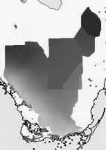
The map to the right shows the location and data status for 1991-1999 EDEN water-level surfaces. [larger version] A spreadsheet lists all gages in the EDEN network used in the surface-water model (.xls file, 71 KB), period of measured data, and whether they were hindcasted back to 1990 (based on type of gage, i.e. structure gage). A tab-delimited text file is also availble for this data set. |
 |
Users are cautioned about the quality of the water-level surfaces for several subareas and in the vicinity of several gages prior to using the data: