Evapotranspiration Data
Data Download Help Page
The Evapotranspiration Data Download tool allows users to download evapotranspiration data and associated parameters for stations in tab-delimited or CSV (comma-separated values) text format, which may then be imported into most spreadsheet or database programs. Users may select any subset of eight variables and five stations for which one would like data, for any period between 2007-04-18 and 2018-06-13. Data is provided as a .zip file containing text files with the data you have requested along with a "readme" file describing the data collection.
An interactive Google Map application provides the location of the
stations with data being served in the Evapotranspiration Database. Information provided upon activating station pins includes
station name, station latitude and longitude, height of tower, vegetation and substrate, period of record, and measured parameters.
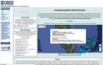
Data from the Evapotranspiration Database may be obtained by
selecting the following parameters:
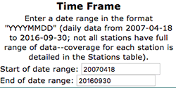
Time Frame
 |
| Not all stations have a full range of data - coverage for each station is detailed in the "Stations" section. |
|
Enter a date range in the format "YYYYMMDD". Data is provided at 15 minute intervals from 2007-04-18 to 2018-06-13. Not all stations have a full range of data - coverage for each station is detailed in the Stations section. The data set will be returned containing all data within the selected date range, even if coverage does not extend to the entire range for all sites.
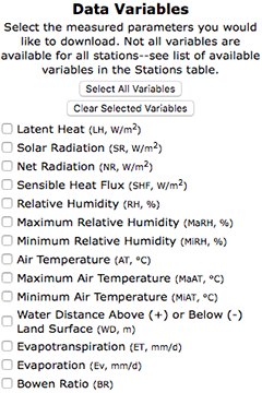
Data Variables
 |
| An Output Option of "By variable" will generate an output file for each selected variable, each of which will contain columns for all selected stations. |
|
Select the measured parameters you would like to download. Not all variables are available for all stations. The following measured parameters are available for some stations (variable abbreviations and units in parentheses):
- Latent Heat (LH, W/m2)
- Solar Radiation (SR, W/m2)
- Net Radiation (NR, W/m2)
- Sensible Heat Flux (SHF, W/m2)
- Relative Humidity (RH, %)
- Maximum Relative Humidity (MaRH, %)
- Minimum Relative Humidity (MiRH, %)
- Air Temperature (AT, °C)
- Maximum Air Temperature (MaAT, °C)
- Minimum Air Temperature (MiAT, °C)
- Water Distance Above (+) or Below (-) Land Surface (WD, m)
- Evapotranspiration (ET, mm/d)
- Evaporation (Ev, mm/d)
- Bowen Ratio (BR)
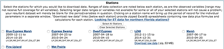
Stations
 |
| An Output Option of "By station" will generate an output file for each selected station, each of which will contain columns for all selected variables. |
|
Select the stations for which you would like to download data. Ranges of data collection are noted below each station, as are the observed variables (range may not receive full coverage for all variables). Selecting larger date ranges or variables not available for some or all of your selected stations will not cause a problem; your resultant dataset will merely be blank for the period/variables in question. The location of these stations can be found on the Google Map.
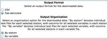
Output Format
Select an output format for the downloaded data. Data may be
downloaded as either CSV (comma-separated values) or tab-delimited
text format.
Output Organization
Select an organization option for the downloaded data. "By station"
denotes individual text files will be created for each selected
station, with columns for all selected variables in each station file,
and rows for every time increment in the selected date range. "By
variable" denotes individual text files will be created for each
selected variable, with columns for all selected stations in each
variable file, and rows for every time increment in the selected date
range.
 |
| Data may be downloaded as either CSV (comma-separated values) or tab-delineated text format. |
|
Download Data
Data is downloaded by clicking on the "Download Data" button. The data will be provided as a compressed zip file and will contain the files you requested along with a readme file describing the data.
 |
| Data may be downloaded as either CSV (comma-separated values) or tab-delineated text format. |
|
|
| Disclaimer | Privacy Statement | Accessibility |
U.S. Department of the Interior, U.S. Geological Survey
This page is: http://
Comments and suggestions? Contact: Heather Henkel - Webmaster
Last updated: (KP)