Due to a lapse in government funding, this website is not currently being updated. For more information please visit: www.doi.gov/shutdown.
| Important Information |
|---|
|
Update: Version 2.0.1 is now available (November 2012), for PC and Mac. See installation information below.
|

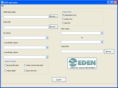
EDEN xyLocator is a program for extracting data from spatial hydrology time-series. Data is extracted for specific x,y positions over the time range supplied by the user. The user can also choose among outputs for water stage, water depth, ground elevation (DEM), and days since dry-down (counting from the start of the specified time range).
The user supplies EDEN xyLocator with a tab-delimited or comma-delimited text file. The first row is a header. Each following row is a point position that the user wants extracted from the EDEN dataset. The row must include a position name, x coordinate and y coordinate. Coordinates must be in UTM, zone 17N, NAD83 projection.
| Installation |
|---|
|
Prior versions of the xyLocator required the user to download NetCDF .dll files and the .NET Framework. This is no longer required, as the latest version of the xyLocator is Java-based. All necessary files are included in the zip file (see below), except for the Java installation. Users will need to have 32-bit Java Virtual Machine (JVM) installed on their system before they can run the xyLocator. The 64-bit JVM causes issues with the xyLocator, so if you are running a 64-bit system, please ensure you have the 32-bit JVM installed, not the 64-bit one. Please contact us if you have questions. User's Guide (pdf, 204 KB, updated November 21, 2012) You will need the following files:
Required User Input Files:
|
| We're looking for feedback! Please contact us. |
The EDENapps are no longer available on CERPZone. Java-based versions of EDENapps are downloadable at: http://sofia.usgs.gov/eden/edenapps/index.php
