Due to a lapse in government funding, this website is not currently being updated. For more information please visit: www.doi.gov/shutdown.
| Important Information |
|---|
|
Update: Version 2.0.1 is now available (February 2013), for PC and Mac. See installation information below.
|

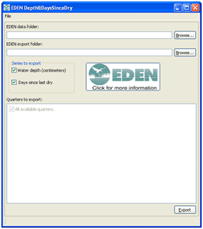
EDEN Depth&DaysSinceDry is a program for creating daily surfaces (in NetCDF file format, .nc) of water depth and days since dry from EDEN daily water level surfaces and ground elevation model.
The daily surface of water depth is created by subtracting the ground elevation for the EDEN grid cell (400 meter by 400 meter cells) from the water level surface. The days since last dry indicates the number of consecutive days since the start of the time period that an EDEN grid cell surface has had a depth value greater than zero. A count of "0" indicates that the cell was wet for that day. Once the cell is dry, the count begins and continues until a wet day is encountered. When this happens, the count is returned to "0".
All water level data are output in units to North American Vertical Datum of 1988 (NAVD88).
Note: the latest version of the Depth&DaysSinceDry Tool was updated with new "Days Since Dry" calculations as well as the ability to select an output path for files. Please see the User's Guide (below) for more information.
| Installation |
|---|
|
Prior versions of the Depth&DaysSinceDry required the user to download NetCDF .dll files and the .NET Framework. This is no longer required, as the latest version of the Depth&DaysSinceDry is Java-based. All necessary files are included in the zip file (see below), except for the Java installation. Users will need to have 32-bit Java Virtual Machine (JVM) installed on their system before they can run the Depth&DaysSinceDry. The 64-bit JVM causes issues with the Depth&DaysSinceDry, so if you are running a 64-bit system, please ensure you have the 32-bit JVM installed, not the 64-bit one. Please contact us if you have questions. User's Guide (pdf, 866 KB, updated July 10, 2012) You will need the following files:
Required User Input Files:
|
| We're looking for feedback! Please contact us. |
The EDENapps are no longer available on CERPZone. Java-based versions of EDENapps are downloadable at: http://sofia.usgs.gov/eden/edenapps/index.php
